

NISAR Satellite A NASA ISRO Mission -24
NISAR Satellite A NASA ISRO Mission
Collaboration across space exploration nations is exemplified by the NASA-ISRO Synthetic Aperture Radar (NISAR) mission. NISAR is an initiative of the Indian Space Research Organization (ISRO) and NASA, the top space agency in the United States, that intends to transform our knowledge of Earth’s dynamic processes.
Fundamentally, improved radar imaging technology is at the heart of NISAR, a pioneering project. The NISAR Satellite A NASA Isro Mission aims to provide remarkable detail and precision in observing Earth’s surface and subsurface features using dual-frequency synthetic aperture radar (SAR).
NISAR, an Earth observation satellite that is slated to orbit the world, will be able to gather a wide range of data about our planet by operating across two different radar frequencies. Scientists will gain in-depth knowledge about a wide range of Earth phenomena, including changes in vegetation, ice sheets, landscapes, and even minute movements in the Earth’s crust, thanks to the use of this multi-frequency technique.
NISAR has the potential to open up new vistas in natural hazard assessment, ecological monitoring, climate science, and other domains by utilizing the capability of radar imaging.
Data collected by NISAR is positioned to influence crucial decision-making processes on a worldwide scale, ranging from monitoring the consequences of climate change to supporting disaster response and resource management.
NISAR is essentially a combination of state-of-the-art technology, global collaboration, and scientific curiosity that will hopefully reveal Earth’s mysteries and lead to a better comprehension of its complex systems and operations.
The NASA-ISRO Synthetic Aperture Radar (NISAR) satellite is approaching the completion of its painstaking building phase as of March 26, 2024. This is a major milestone in this ground-breaking collaboration between NASA and ISRO. As the last touches are put on, excitement is growing for the next launch, which is expected to be completed by the end of April.
Follow our Digiknowledge.co.in page for the latest updates about bikes, cars, sports, lifestyle, and many more.
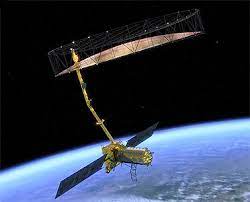
NISAR, which is positioned to transform our knowledge of Earth’s dynamic processes, is a monument to the cooperative spirit between two of the top space agencies in the world. Its sophisticated architecture conceals a dual-frequency synthetic aperture radar (SAR), a marvel of contemporary engineering and scientific creativity.
Given its distinct architecture as a low Earth orbit (LEO) observatory, the NISAR project constitutes a paradigm shift in Earth observation. NISAR is expected to provide an unprecedented amount of dependable, high-resolution data during the course of its three-year mission, in contrast to usual satellite missions.
Crucial to the NISAR goal, Dr. Rosen emphasizes the importance of this data flood and how it could transform a range of scientific and surveillance uses. Researchers will be able to examine Earth’s surface and subsurface features in great detail thanks to NISAR’s superior synthetic aperture radar (SAR) technology, which will provide an unmatched vantage point.
NISAR’s massive data output is expected to pave the way for new developments in areas including disaster response, crop monitoring, and forest management. Scientists, decision-makers, and stakeholders around the world will find NISAR’s data stream to be an invaluable resource for following changes in vegetation patterns, evaluating the effects of natural disasters like hurricanes, and monitoring agricultural output.
NISAR’s usefulness for a variety of applications is further increased by its capacity to deliver accurate measurements over any location on Earth. NISAR enables researchers to gain greater knowledge of Earth’s complex processes and dynamics by providing a reliable and accurate data source. This allows for well-informed decision-making and proactive interventions across a range of areas.
NISAR is waiting impatiently to go out on its cosmic voyage atop a launch vehicle at the Satish Dhawan Space Centre, which is tucked away along southern India. NISAR’s goal to investigate and reveal the secrets of our planet is ideally positioned to take advantage of this important launch location, which is highly regarded for its operational excellence.
Using its cutting-edge radar imaging capabilities to gather a wide range of images of Earth’s surface and subsurface characteristics, NISAR will set out on a mission of transformation once in orbit. Beyond bounds, NISAR’s observations promise to expand our knowledge of the complex systems that control our globe, from monitoring changes in landscapes to investigating ice dynamics and vegetation patterns.
What is NISAR?
The groundbreaking mission NISAR, a joint venture between NASA and ISRO, is intended to track Earth’s changing ice sheets, dynamic surfaces, and ecosystems. It will be the first satellite to obtain complete radar data over two bandwidth zones, using both L-band and S-band microwave frequencies to set a new benchmark in radar imaging. With its dual-frequency approach, Earth’s changing landscapes will be better understood, leading to a deeper comprehension of important environmental processes and phenomena.
What will NISAR measure?
NISAR’s revolutionary capabilities include the ability to measure minute variations in Earth’s surface accuracy, down to the centimeter level. This involves watching the speeds at which glaciers and ice sheets flow, keeping an eye on the dynamics of volcanoes and earthquakes, and providing information on the distribution of biomass. NISAR will also be an essential tool for evaluating natural hazards, predicting sea level rise, and mapping groundwater resources. These tasks will improve our comprehension of Earth’s intricate systems and help decision-makers make well-informed choices in vital areas like environmental management and disaster response.
What is NISAR’s resolution?
With its outstanding resolution ranging from 3 to 10 meters, depending on the operating mode, NISAR is outfitted with synthetic aperture radar (SAR) technology. Scientists may accurately and precisely examine a wide range of events thanks to NISAR’s variable resolution capacity, which enables it to take detailed photographs of the Earth’s surface. With NISAR’s SAR resolution, important insights into Earth’s intricate systems at different scales can be obtained for observing changes in landscapes, tracking ice sheet dynamics, or researching geological characteristics.
What is NISAR’s orbit?
For the best possible Earth observation, NISAR’s orbital parameters have been carefully planned. With a height of 747 km and an inclination of 98.4°, it is positioned in a sun-synchronous orbit that guarantees constant lighting for imaging. NISAR is able to collect precise data as it rapidly circles the Earth every 100 minutes. Its 12-day repeat cycle allows for systematic coverage of the surface of the Earth, making it easier to monitor and analyze dynamic processes in real time.


